Greenwich Connectivity Plan
A community-wide existing conditions analysis paired with extensive public engagement produced a list of priority improvement projects for the Town and Village of Greenwich.Existing Conditions
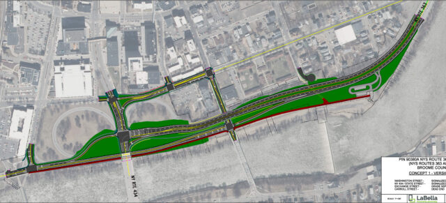
![]()
Alongside a dedicated project committee, LaBella assessed existing conditions to identify potential improvements. While the Village has a network of sidewalks, many lack full ADA accessibility and require upgrades. The Empire State Trail and State Bicycle Route 9 provide existing cycling infrastructure, but additional connections are needed to enhance access to local amenities.
High-traffic routes and intersections—particularly along State Route 29 and Main Street—pose safety concerns due to high vehicle speeds and crash data indicating areas that require attention. Additionally, road slopes vary throughout the Town, influencing route feasibility for cyclists and pedestrians.
![]()
Public Engagement
Identifying the community’s priorities and infrastructure needs required comprehensive public engagement. An interactive web map gathered 75 location-based contributions from community members and 85 comments from 25 unique users. Feedback emphasized the need for bike racks, crosswalks, sidewalk upgrades, pedestrian signage, and traffic calming measures throughout the Village and Town.
![]()
Additional outreach included community meetings, surveys, press releases, digital media, flyers, and interactive displays at the Greenwich Library and Town and Village Halls.
Priority Improvements
With public and committee insights and feedback, LaBella developed recommendations which were advanced to concept level designs. Based on feasibility, demand, and safety considerations, three priority improvement areas, which would also align with community goals and long-term mobility improvements, were identified with the committee:
Empire State Trail Connections![]()
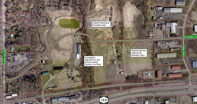
Enhance bicycle connections between the Village and the Empire State Trail, located six miles west of the Village along the Hudson River. LaBella explored both on-road and off-road options to improve regional access for residents and visitors, identifying two primary route options: one utilizing the existing Battenkill railway and the other utilizing the existing roadway network to reach the final destination. The railway alignment was preferred because it can accommodate users of all bicycle comfort levels. Cross sections were developed to assess both the replacement of the rail with a trail and the preservation of the rail with the construction of an adjacent trail.
Route 29 Commercial Corridor
![]() Increase pedestrian and cyclist safety and connectivity along Route 29. A speed, volume, and cross-section assessment was conducted to determine appropriate facility treatments and widths, identify safety considerations, and develop alternative approaches. Key recommendations include filling a sidewalk gap on the south side, creating a shared-use pedestrian and cycling path on the north side, and adding signal upgrades, crosswalks, and curb ramps for ADA compliance.
Increase pedestrian and cyclist safety and connectivity along Route 29. A speed, volume, and cross-section assessment was conducted to determine appropriate facility treatments and widths, identify safety considerations, and develop alternative approaches. Key recommendations include filling a sidewalk gap on the south side, creating a shared-use pedestrian and cycling path on the north side, and adding signal upgrades, crosswalks, and curb ramps for ADA compliance.
Academy/Church/Main/Cottage Intersection
![]() Improve accessibility for pedestrians and overall operations at this complex intersection, which poses safety challenges, particularly for students who frequent the route to the school, library, and youth center. Observations, data collection, and analysis were performed to assess vehicle and pedestrian conditions and identify any collision patterns or frequencies. The usage data was analyzed to determine appropriate intersection control treatments and other physical traffic calming and crossing improvements. The recommended improvements include adding curb bump-outs, realigning crosswalks, and evaluating the installation of all-way stop signs or a traffic signal to enhance safety and traffic flow.
Improve accessibility for pedestrians and overall operations at this complex intersection, which poses safety challenges, particularly for students who frequent the route to the school, library, and youth center. Observations, data collection, and analysis were performed to assess vehicle and pedestrian conditions and identify any collision patterns or frequencies. The usage data was analyzed to determine appropriate intersection control treatments and other physical traffic calming and crossing improvements. The recommended improvements include adding curb bump-outs, realigning crosswalks, and evaluating the installation of all-way stop signs or a traffic signal to enhance safety and traffic flow.