Mapping Memories: Modernizing Cemeteries Using GIS Technology

Cemeteries are more than final resting places. They are cultural landmarks honoring loved ones and preserving the legacies of historical figures, war veterans, and others whose stories shape our collective history. In recent years, these spaces have also become destinations for “tombstone tourists,” drawn to their architectural beauty, landscaped grounds, artistic monuments, and unique photography opportunities.
The bridge between preserving our history and meeting the needs of the present lies in mapping. Mapping is a practical necessity for cemeteries; however, many cemeteries still rely on traditional paper records and hand-drawn maps, leaving them vulnerable to inaccuracies and inefficiencies.
By integrating Geographic Information System (GIS) technology, cemeteries can transition from outdated systems to powerful digital platforms that safeguard records, streamline operations, and engage the public in meaningful new ways.
Challenges to Maintaining a Cemetery’s Information
Maintaining essential business data through outdated record-keeping and mapping methods presents several concerns for cemeteries, including:
- Vulnerability of Paper Records: Paper records are highly susceptible to deterioration, loss, or damage. Environmental threats such as floods and fires, along with mishandling or misplacement, make it increasingly difficult to maintain accurate burial records over time.
- Limited Records Search Capabilities: Locating specific burial sites in a traditional system requires manual searches through books, card catalogs, or paper maps—a time-consuming process prone to errors. Without digital tools, cemetery staff and visitors must rely on physical maps and walking the grounds to locate plots, complicating efforts to find burial sites or notable cemetery features efficiently.
- Inefficient Cemetery Grounds and Burial Plot Management: Without centralized digital mapping, managing burial plots and planning for future use becomes cumbersome. Outdated records increase the risk of errors, such as misallocated plots, and hinder the ability to efficiently track availability or plan for future expansions.
The Role of GIS in Cemetery Mapping
GIS technology, paired with modern data management tools, offers a transformative solution—ensuring critical records are preserved for future generations while streamlining daily operations. So, how can a cemetery get started?
Data Collection and Management
To develop and implement a GIS program for a cemetery, several key components are required. At its core, this includes a digital map, a digital database of burial records, and optionally, digital media such as photographs to provide additional visual details of important cemetery features (e.g., headstones, monuments, vegetation).
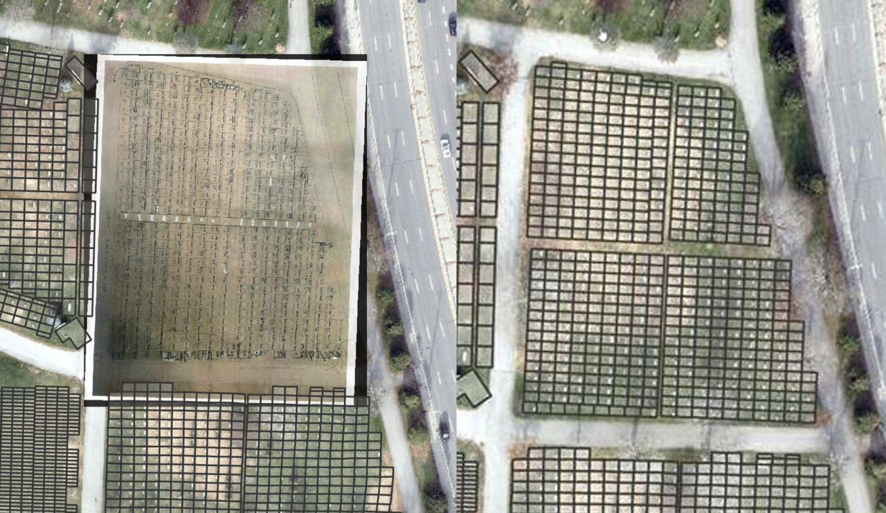
- Digital Mapping: The most accurate cemetery maps are created through professional surveys, which capture plot boundaries and photograph headstones. Alternatively, old paper maps can be scanned, georeferenced to align with real-world coordinates, and digitized into GIS data. For cemeteries without prior mapping, GIS specialists can still create digital maps, especially for uniform plot layouts. For example, a section measuring 40 plots wide by 80 plots long can be mathematically modeled to construct plots. Surveys of headstones can further refine these maps, ensuring accuracy even in the absence of prior documentation.
- Digital Database Conversion: In addition to digitally mapping plot locations, burial data must be converted into a structured database format. Using tabular data software, such as Microsoft Access or Excel, enables seamless integration with GIS for efficient searching and visualization. Cemeteries with existing digital records can streamline this process. For those still using paper records, manual transcription is possible in small cemeteries, while larger cemeteries can benefit from intelligent document processing (IDP) platforms like ABBYY Vantage, which use state-of-the-art artificial intelligence (AI) and machine learning to automate large-scale data conversion processes. AI-driven tools can significantly reduce the time and cost of transitioning to a digital system, ensuring a faster, more efficient conversion.
Mapping Solutions and Spatial Analysis
Once a cemetery has developed its digital map and database, it can implement a GIS solution to share information with the public. Platforms like ArcGIS Online, developed by the Environmental Systems Research Institute (Esri), offer robust features to enhance accessibility and engagement, including:
- Navigable Online Maps: Accessible via web browsers and mobile devices, these interactive maps allow users to zoom, toggle layers, easily locate graves or other areas of interest, and view related information or photos.
- Advanced Search and Data Filtering: GIS-based online mapping tools offer advanced search capabilities that help users quickly find grave sites by name, date of death, section, and other criteria. Users can refine results with filters and view precise map locations for easier visit planning.
- Beyond Burial Information: While burial data is central to a GIS program, mapping additional features such as monuments, famous burials, unique vegetation, and office buildings enhances the visitor experience and supports cemetery operations. This information can be further enriched with descriptive narratives, photographs, and other media.
Benefits of GIS Cemetery Mapping
Implementing a GIS program for cemetery mapping offers significant, long-term benefits in three key areas:
- Improved Record Keeping and Data Management: Moving to digital record storage ensures information is safe from physical damage. Additionally, cloud-based GIS systems provide secure, off-site storage and easy access to data from a single authoritative source. Both staff and the public can turn to this centralized system for the most current and accurate information.
- Operational Efficiency: GIS streamlines processes like plot sales, displaying availability on color-coded maps that update in real time. These maps can also be accessed online, allowing prospective buyers to explore options independently, saving time for both staff and visitors. Additionally, GIS tools support efficient grounds maintenance by aiding in vegetation management, planning, and scheduling.
- Public Engagement and Accessibility: GIS enhances visitor experiences by enabling easy grave location searches, freeing staff for other duties. Online tools extend access beyond business hours, allowing users to explore burial sites, monuments, and other features independently. Platforms like Esri’s ArcGIS StoryMaps can further engage visitors with guided tours, showcasing a cemetery’s historical and cultural significance.
Bridging the Past and Present Using GIS Technology
GIS technology offers cemeteries an invaluable opportunity to address long-standing challenges while embracing their roles as places of remembrance and community significance. Transitioning from paper records to dynamic digital platforms ensures the preservation of vital information, optimizes daily operations, and enhances visitor experiences. Tools like Esri’s ArcGIS Online and AI-powered data conversion make these advancements accessible to cemeteries at any stage of modernization.
By leveraging GIS, cemeteries can honor their history while adapting to modern needs, creating enduring spaces that celebrate heritage, foster community engagement, and remain cherished cultural landmarks for generations to come.

About the Author
Insights by Rebecca Smith, GISP: