From Data to Development: The Power of GIS Technology in Municipal Planning

Geographic information system (GIS) technology is revolutionizing urban planning by providing powerful tools for collecting, analyzing, and visualizing data related to demographics, housing, land use, and community needs, facilitating data-driven decision-making. These tools can be used to inform policy recommendations and development strategies, ultimately transforming neighborhoods.
Our recent GIS-supported strategic planning project in the Mid-City neighborhood of Niagara Falls, New York, is a prime example of how integrating GIS technology with stakeholder collaboration and community engagement can effectively drive meaningful urban revitalization.
Understanding GIS Technology
GIS technology integrates location data (where things are) with descriptive information (what things are like there) to create visual representations and perform data analysis, which together can reveal geographic patterns, relationships, and trends. By connecting data to a visual representation such as a map or 3D model, GIS helps users understand and interpret data in a way that can be used to inform decision-making and problem-solving in various fields, including urban planning and community development.
The Mid-City Project
The Mid-City GIS project in Niagara Falls, New York, led by LaBella Associates in partnership with Niagara University and the Niagara Falls Neighborhood Evaluation Committee, utilized GIS technology to inform strategic planning and decision-making. Specifically, this initiative aimed to thoroughly evaluate housing and community conditions and identify areas for targeted investment in the Mid-City area.
The GIS-driven planning initiative involved working with a steering committee with key stakeholders, including the City of Niagara Falls Planning Department. The committee’s primary goal was to develop a comprehensive housing strategy to improve housing affordability, identify development opportunities, and enhance the overall quality of life for residents, especially historically marginalized groups.
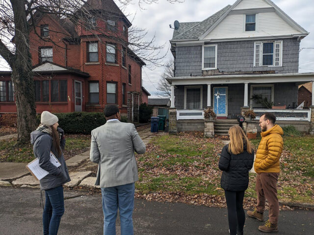
The project involved three main steps: community engagement, housing surveys, and the development of an interactive web mapping tool. Community engagement included hosting open houses and webinars to inform the public and gather insights on local opportunities and challenges, as well as collaboration with Niagara University students for field data collection and GIS analysis.
Housing surveys assessed 3,320 parcels in Mid-City through a general “windshield” survey, rating them from 1 (dilapidated) to 4 (good), and provided a detailed appraisal of 357 houses in two selected areas, evaluating foundations, facades, roofs, and windows on a scale of 1 to 5.
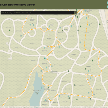
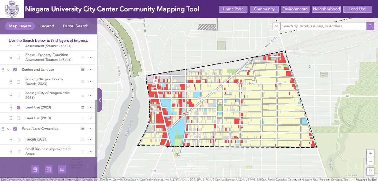
The final product was an interactive online community mapping tool created using ArcGIS Experience Builder and ArcGIS Hub. This tool aggregates all collected data, making it accessible to the City of Niagara Falls, its partners, and the public. It serves as a repository for data to support future development initiatives, policy formulation, and grant funding applications. A webinar was hosted to introduce the mapping tool to interested parties, highlighting its data collection methodology and potential uses.
In July 2024, LaBella and Niagara University were honored to receive a 2024 Special Achievement in GIS Award from the Environmental Systems Research Institute (Esri) for the Mid-City GIS-supported strategic planning project in Niagara Falls.
Leveraging GIS Technology for Municipal Strategic Planning
Integrating GIS technology into strategic planning and community development can provide municipalities with powerful tools for data-driven decision-making. The Mid-City project in Niagara Falls offers several valuable insights—discussed in the sections that follow—into the implementation and benefits of GIS-supported strategic planning.
Partner With GIS Experts
Collaborating with GIS firms or experts ensures that the necessary technical skills for data analysis and mapping are available. Niagara University and the Niagara Falls Neighborhood Evaluation Committee engaged LaBella’s GIS experts to provide the technical expertise needed for the successful integration of GIS technology into the Mid-City project.
Development of Interactive Tools
The creation of interactive web mapping tools allows municipalities to visualize a wide range of data geographically, identify areas needing attention, and track progress over time. Tools developed using online platforms make data easily accessible to key stakeholders as well as the public. In addition, providing regular workshops and training sessions ensures that stakeholders understand how to effectively use GIS tools and data.
The Mid-City project utilized ArcGIS platforms to create an interactive online web mapping tool that serves as an easily accessible resource for the City of Niagara Falls. Following development, a webinar was held to introduce the tool, providing an overview of its data collection methodology and potential applications to stakeholders. This central data repository will be instrumental in helping the City and its partners establish a comprehensive housing strategy backed by actionable goals that are supported by real-life conditions.
Informed Decision-Making and Efficient Resource Allocation
GIS technology enables municipalities to collect and analyze a wide range of data, including local demographics, land use, housing conditions, and access to community facilities. This comprehensive analysis helps city planners identify areas that need investment and develop targeted strategies to address specific needs. By pinpointing areas requiring attention, municipalities can allocate resources more effectively, ensuring that investments and policies have maximum impact.
In the Mid-City project, analysis of GIS data on demographics, land use and zoning, income and employment, housing conditions, transportation, recreational opportunities, and other variables provided vital insights. This information was used to determine key areas for improvement, support data-driven decision-making, and shape effective policy and development recommendations.
Grant Funding Support
A centralized data repository and interactive web mapping tool can provide clear, evidence-based justifications for funding requests, helping municipalities strengthen their grant applications.
The GIS-based community mapping tool developed in the Mid-City project was designed to serve as a comprehensive data source. During the webinar introducing the tool, emphasis was placed on its role in supporting grant applications and the potential for integrating additional data sources to aid future community development efforts.
Collaboration Among Key Stakeholders
Forming a committee of key stakeholders, including local government, community organizations, and educational institutions, enriches the project with varied expertise and diverse perspectives.
The GIS-driven planning initiative in the Mid-City project involved working with a steering committee of key stakeholders that included the City of Niagara Falls Planning Department, the Niagara Orleans Regional Land Improvement Corporation, Niagara Area Habitat for Humanity, and LISC New York.
The committee set the guidelines for data collection, which will pave the way for developing a comprehensive housing strategy, highlighting the significance of collaborative efforts in urban planning.
Community Engagement
Engaging residents and stakeholders through a variety of methods, such as surveys, webinars, open houses, and public meetings, fosters community buy-in and ensures that development initiatives align with community needs and priorities.
Community engagement via open houses, webinars, and Niagara University student involvement played an essential role in the success of the Mid-City project. These efforts informed the public about the project, gathered insights on local opportunities and challenges, and actively involved the community in the planning process.
Empowering Communities With GIS
The Mid-City project in Niagara Falls demonstrates the transformative potential of GIS technology in urban planning. By adopting similar practices, municipalities can effectively harness GIS technology to enhance their strategic planning through data-driven decision-making, achieving more impactful development initiatives.
Partnering with a GIS expert like LaBella can help bring these benefits to your community. With our Data Intelligence Group’s specialized skills and expertise on board, municipalities can successfully implement GIS-supported mapping and planning to drive meaningful community development and urban revitalization.

About the Author
Insights by Rebecca Smith, GISP: