Embracing Nature: Climate-Adaptive Strategies for Parks and Recreational Spaces


As communities nationwide face increasing risks from sea level rise, storm surges, and flooding, municipalities are rethinking how public spaces—especially those along waterfronts—can play a larger role in protecting people, property, and ecosystems.
Rather than trying to fight nature as we have in centuries past, many municipalities are now adopting climate-adaptive design strategies that work with natural systems—such as wetlands, floodplains, and native vegetation—to manage water, absorb impacts, and enhance the quality and accessibility of parks and recreational spaces. This approach helps ensure these spaces remain safe, functional, and ecologically beneficial for decades to come.
Understanding the Local Landscape
Wetlands, floodplains, soil types, topography, and community needs have long influenced park and recreational planning. Today, municipal leaders must also consider how climate change will affect conditions over time and plan for public spaces that can adapt accordingly.
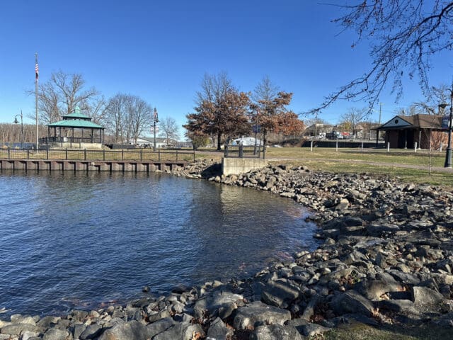
In Hudson, New York, the city is reimagining Henry Hudson Park with future conditions in mind. Located along the Hudson River, the existing seven-acre park is already heavily impacted by flooding—an issue expected to worsen, as sea levels are expected to rise by as much as five feet by the year 2100. This would put a significant portion of the park at risk. The planning process has focused on balancing these projected climate impacts with long-term park goals and public input. For example, extensive community engagement helped shape the overall design vision, and a previously completed invasive plant species survey informed a removal plan. As part of this planning effort, sea level rise modeling was used to demonstrate projected conditions at the park to the public.
In St. Petersburg, Florida, the city’s resilience master plan emphasizes the need to plan and design for a future where parks and green space can serve as the first line of defense against sea level rise, storm surge, and other climate vulnerabilities. With waterfront parks along Tampa Bay and the Intracoastal Waterway, park officials are restoring wetlands and installing living shorelines—stabilized, vegetated banks that provide a gentler transition to the river and help absorb storm surges and filter runoff.
Working With Nature, Not Against It
Historically, flood-prone areas were often armored with concrete or elevated with imported soil to improve resilience—strategies that can be effective but are also costly, unsustainable, and disruptive to ecosystems.
Today, more resilient outcomes are being achieved by working with natural features like floodplains, wetlands, and waterways rather than trying to control them. This approach helps ensure parks remain safe, functional, and ecologically beneficial for decades to come.
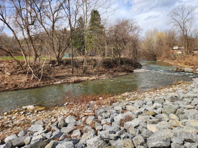
At Lake Erie Beach Park in Evans, New York, a decades-old attempt to reroute Muddy Creek aimed to expand beach access but instead led to increased erosion and flooding. The creek frequently bypasses the redirected outlet and flows along its original path through the park. A new design strategy calls for removing the concrete retaining wall and allowing the creek to follow its natural course, reconfiguring the park’s layout while supporting a larger, more stable beach area. This approach is expected to reduce vulnerability to future storm events, restore the ecological function of the creek corridor, and enhance long-term public access.
Plans for the reimagined Henry Hudson Park in Hudson, New York, include forming an intertidal wetland area by excavating part of an existing peninsula. As part of this excavation, wooden crib walls that currently block water connectivity will be replaced with planted living shorelines. Soil removed from the peninsula will be used to build up the tip of the landform, which will eventually become a small island used for fishing as sea levels rise. A new pedestrian pier has also been designed to remain usable at elevated water levels but also to withstand temporary submersion during severe flooding.
In Virginia Beach, Virginia, a multi-site restoration project along the eastern branch of the Elizabeth River will transform public parks into climate-resilient spaces. At Woods of Avalon Park, Carolanne Farms Neighborhood Park, and Ferry Point Park, plans include wetland and floodplain restoration, living shorelines, and stabilization of stormwater ditches. Nature-based features like native vegetation, coir logs, and hardwood logs will be used to reduce erosion, improve water quality, and restore degraded marsh systems. These efforts aim to buffer shorelines, reconnect riparian habitat, and manage flooding in low-lying areas vulnerable to storm surge and tidal flooding.
These strategies prioritize resilience—the ability of an area to recover following extreme weather events, such as flooding, heat waves, or severe storms—over reliability, which is the ability to maintain continuous use even during such events. By planning for temporary inundation rather than trying to prevent it entirely, municipalities can reduce long-term costs while preserving public access.
Integrating Engineering With Ecological Solutions
Traditional engineering methods still play a key role in park design—but many municipalities are now combining structural strategies with natural processes to enhance performance and reduce environmental impacts. While this may involve setting aside some land for flood storage or ecological buffers, these areas can often double as recreational and educational opportunities.
At Rodney Cook Sr. Park in Atlanta, Georgia, green infrastructure and engineering work in tandem to manage stormwater and reduce flood risk in Vine City—a neighborhood historically prone to flash floods. Spanning 16 acres, the park includes a two-acre retention pond and a network of green infrastructure features such as native plantings and rain gardens. Together, these elements can manage up to nine million gallons of rainwater during a single storm. The system filters and gradually releases stormwater to help prevent downstream flooding.
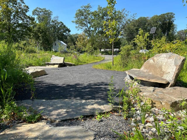
Hydrologic modeling along the West Branch Limestone Creek in Manlius, New York, helped identify floodplain storage sites that would reduce the potential for downstream flooding and erosion. Several of these floodplain areas could be used as recreational areas, improving public access to the water while also offering opportunities to educate the public about the importance of floodplain storage in flood mitigation.
Local officials in Evans, New York, are exploring recommendations to purchase frequently flooded properties along Muddy Creek at Lake Erie Beach Park and convert them into undeveloped floodplains, which could provide natural recreational spaces while improving flood management. The feasibility study also recommended incorporating educational signage in these recreational spaces to help the public understand their purpose and flood management benefits.
The redesign of Henry Hudson Park in Hudson, New York, focuses on diverting floodwaters to create new park features, allowing the park’s aesthetics and uses to change over time. Key elements include rain gardens to capture and treat stormwater, the reuse of trees slated for removal as materials for nature paths and a natural playground, and living shorelines that use plants to stabilize slopes rather than riprap. Once established, these plantings require minimal maintenance and do a better job of preventing shoreline erosion. As part of the design, educational signage is being integrated into the park to educate the public about the importance of native plantings, living shorelines, and sea level rise.
Practical Takeaways for Municipal Leaders
As more towns and cities plan for future climate conditions, several key strategies have emerged:
- Embrace natural transitions: Replacing vertical walls with gently sloped banks and living shorelines can improve flood resilience and enhance ecological value.
- Consider long-term maintenance: Once established, nature-based solutions often require less upkeep than traditional infrastructure and recover more easily after extreme weather.
- Build in flexibility: Features like floating docks and seasonal structures allow parks and waterfronts to adapt as climate conditions change.
- Engage early: Collaborating with local stakeholders, ecological scientists, and regulators from the beginning ensures design feasibility and builds community support.
Looking Ahead
Climate-adaptive design doesn’t have to come at the expense of public access, aesthetics, or recreational value. In fact, many communities are finding that these approaches offer more lasting benefits—from reduced repair costs to improved ecological health and enhanced public use. With thoughtful engineering and ecological awareness, municipal leaders can create spaces that not only meet the needs of today’s residents but also safeguard those of future by preparing for rising waters, extreme weather events, and changing conditions. As more communities adopt this approach, the path forward becomes clearer: don’t resist change—design for it.